The challenges of calculating a sustainable Atlantic salmon (Salmo salar) management conservation targets in balance with juvenile habitat in small salmon rivers. Brendan Kerr 2020
Abstract
A habitat analysis of five small rivers was conducted in two small river systems, one in North West Ireland, Teelin Co. Donegal and one in North East Ireland, Ballycastle Co. Antrim. ARC GIS was used to map and quantify nursery habitat containing spawning habitat and spatially connected to spawning habitat. Nursery habitat connected to spawning habitat or containing spawning habitat was analysed as a sub-set of fluvial area within individual rivers. A trial method to estimate habitat based productivity and a habitat based conservation target is presented. A model of juvenile productivity based on nursery habitat spatially connected to or containing spawning habitat indicated that an adult /smolt sea survival ratio of around 0.2 necessary for sustainable utilization of nursery habitat by salmon fry and future sustainability. Spatially locating and quantifying nursery habitat proximally close to spawning habitat provided useful insights into physical habitat differences between studied rivers.
Introduction
My aim in writing this paper is to communicate a perceived need to monitor individual river salmon populations in relation to specific juvenile habitat areas, i.e. spawning and nursery habitat as a sub set of total fluvial area in individual rivers. A habitat based profile of nursery habitat spatially connected to spawning habitat as a subset of fluvial area would improve the specificity of conservation target estimates in individual rivers. The spatial connectivity and area of nursery habitat differed and has implications for estimating potential productivity and conservation targets for individual rivers.
In 2020 angling catch returns have been declining, despite strict conservation measures and redundant commercial fisheries. Many speculate that salmon farm induced sea lice infestations, diseases and genetic dilution of individual populations from farm escapes are a cause of the decline (ICES 2006, Ford 2008). In recent decades large rivers on the East Coast of Scotland/UK where there was no salmon farming appeared to be doing well and bucking the trend. The river Tweed in particular was going from strength to strength assisted by a strong angling community and the Tweed Foundation, a science based charity, funded by donations from angling interests. The Tweed reported its highest ever salmon rod catch in 2011, over 20,000 salmon. However by 2019 its’ lowest ever catch was recorded (c5000, Tweed Foundation) despite voluntary catch and release over many years. In republic of Ireland (ROI) 64 of 147recognised salmon rivers are closed to harvesting of any salmon stock with 34 open on a catch and release basis only (IFI 2020). Whilst 49 rivers (2021) in ROI allow a small harvest based on an estimated surplus above an estimated conservation limit the reduced availability of rivers open to angling has negative consequences for tourism revenues. In Northern Ireland salmon all rivers are closed to harvesting of any salmon as stocks are so low (2016-date).
The North Atlantic salmon Conservation Organisation (NASCO) identifies the need for an audit of Atlantic salmon freshwater habitat recognising that rivers are the nurseries of a potentially harvestable North Atlantic mixed stock population. The International Council For the exploration of the Sea (ICES) collates and analyses salmon monitoring data collected by regional Governments and functions via specific protocols for scientific reporting. All countries signed up to NASCO are focused on broad overarching goals including assessment of pre fishery abundance targets for commercial fishing of adult salmon in the ocean and coasts. National commitments by NASCO affiliated states working through Government departments such as Dept. Agriculture Environment and Rural Affairs (DAERA) in NI, Inland Fisheries Ireland (IFI) and European Union platforms work collectively to conserve, restore, enhance and rationally manage wild Atlantic salmon supporting specific targeted projects in salmon science. Charities such as the Atlantic Salmon Trust, Tweed Foundation, Rivers Trusts, community groups and angling clubs work closely within the context of the Water Framework Directive (WFD) and to deliver national environmental strategies supporting Atlantic salmon conservation. Index rivers are used to produce a reference temporal stock recruitment profile which enables stock estimates to be extrapolated to non-index rivers (Prevost 2003), providing a management decision baseline. Recently resources have been deployed to assess smolt output and survival (Smoltrack and Sea Monitor)) in selected rivers, rivers to monitor adult returns to the coast in relation to smolt output from rivers.A salmon management model might conclude that sufficient smolt output and sea survival (smolt → returning adult) is essential to ensure a self-sustaining population. However all life cycle stages (ova, alevin, fry, parr, and smolt) need to be considered in developing a realistic population model for individual rivers.
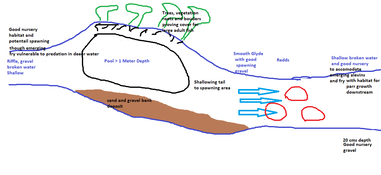
Quantitatively assessing rivers as salmon producing habitat requires consideration of three main habitat types, nursery, spawning and holding habitat (Cowx 2003)Two of these are assessed in this study, spawning and nursery. Measuring habitat attributes of a stream (Heggenes 1999; Milner 1993), in this case using a simplified version of a Life Cycle Unit System (LCUS DANI 2000, O’Connor and Kennedy 2002) was used to assess the area of nursery habitat in close spatial proximity to spawning habitat. The three main habitat types are presented below.
- Spawning areas in November/ December to facilitate egg- laying require river bed gravel of a specific size, stability and flow to facilitate digging of a nest by female egg laying salmon. They are often in shallow glides at the exit of pools, but can also be mixed in with areas of nursery. Spawning areas are generally swift flowing areas where water flow is capable of moving gravel downstream as the female cuts and disturbs the gravel to create a hollow and cover eggs with gravel. Adequate water flow is required to ensure that the redd is covered by water at all times (Hendry 2003).
- Nursery areas require a well stoned bed, which provide shelter, a supply of food and a competitive territory. Shallow fast flowing water provides protection from predation by larger fish and the rippling effects protect them from predation by birds (Hendry 2003). Generally these are areas of riffle which provide fast moving well oxygenated water.
- Holding areas are necessary to enable adult salmon to ascend the river and offer a secure resting area where minimum energy is required to sustain the fish until spawning time. They are identified by deep water, fast or slow moving and provide security and shelter (Hendry 2003).
With current low sea survival and relatively low population numbers, Atlantic salmon are at risk of stabilising at a low level unviable for commercial harvesting or angling and sustainable survival. With sea survival as the main suspect resulting in declining salmon populations it remains essential that rivers are managed as Atlantic salmon habitat so that sufficient juveniles continue to be produced naturally.
A key management criteria used for salmon management decision making is the conservation limit. The term conservation “limit” is used to indicate a habitat based limit for productivity and suggests that any additional juvenile abundance in a particular river would be counterproductive. The conservation limit is generally determined as ova numbers, expressed as adult female fish required to ensure sufficient smolts are produced to maintain sustainable returns of adult salmon in particular rivers. Now, that current sea returns are of concern it may be appropriate to substitute the term conservation limit with conservation “target” as conservation limits are often not achieved. Any harvestable surplus would need to be accounted for as a management target and would be greater than the conservation target to safely accommodate any stock exploitation.
The established Bayesian method for estimating Atlantic salmon conservation limits in Ireland is illustrated by (White 2016).This relies on temporal biological reference points (BRPs), (Crozier 2003; Prevost 2003; Myers 2001; Kennedy 1995; Chaput 1998; Williams1999). BRPs are determined from historic trend estimates of egg deposition from mature egg carrying females. BRPs utilize Beverton-Holt and Ricker, models, and provide a “hockey stick”,stock –recruitment curve relationship between historic spawning stock biomass (White 2016, Subby 2014), and estimated smolt output. The flattening of the hockey stick curve reflects a density dependent maximum output of juveniles from a river system.
Empirical studies demonstrate that the majority of juvenile, young of the year, (0+, fry) salmon are found spatially proximal to the location where they were deposited as alevins (Borsanyi 2004; O’Connor 2002) and require nursery habitat in close proximity to spawning habitat to survive (Armstrong 2005; Hendry 2003; Farooqi 1995). A study from the river Bush Salmon station in Northern, Ireland found that 70% of stocked alevins were recovered by electrofishing within 100m of where they were deposited four months after stocking (Kennedy 1982). Other studies found no fry more than 400m from the stocking location (Egglishaw 1980) and the median distance from egg to fry was found to be 41m (Armstrong 2005). (Bealle 1994) found that 71% of surviving fry were found within 200 m downstream and 91 % within 400 m downstream. Parr were found to migrate further than fry as they grow and develop taking up residence in deeper territories with increased gradients and larger substrate size.
Survival and growth of juvenile salmon is dependent on competition and the amount of available space (Kennedy 1994). The presence of older age classes has a weak negative effect of growth of fry as noted in previous studies (Eggilshaw 1980, Kennedy 1986, Crisp 1993). Juvenile salmon survival is reported to be density dependent (Gee, A., Milner, N., & Hemsworth, R. (1978). It is suggested that estimates of juvenile productivity need to take account of the spatial differentiation between habitats and functional habitat (Kocik 1998). A functional habitat unit can be defined as an area of nursery habitat spatially connected to spawning habitat.
Studies have evolved towards understanding productivity in relation to fluvial wetted area (IFI 2015; McGinity 2012; Armstrong 2003; Hendry 2003 Williams 1999). but have not specifically assessed productivity bottlenecks constrained by individual life cycle habitat units such as nursery habitat in close spatial proximity to spawning habitat. It is known that river habitat capacity for fry(<0+yrs/ young of the year) productivity is limited by density dependent competition (Enium 2011, 2008; Imre 2005; Steigerson 1999; Kennedy1986; Kennedy 1984 Egglishaw 1980) in nursery habitat. Whilst juvenile river habitat is to an uncertain extent accounted for by assessing fluvial wetted area, this does not account for the limiting effects of density dependent competition in available nursery habitat to estimate life cycle populations such as fry and parr, where the quantity of defined in river nursery habitat limits juvenile productivity.
It is reasonable to expect the area of nursery habitat can determine carrying capacity, regulate productivity and that the fish population is limited by the nursery habitat available. The extent to which hydro-geomorphological habitat area within individual rivers is accounted for in defining salmon populations is unclear from the literature. Refinement of the established models prented in (White 2016) and accounting for a detailed habitat analysis of individual rivers as a subset of fluvial area (as presented in McGinity 2003) would provide an enhanced precise estimate of conservation requirements in individual rivers.
Fluvial area varies greatly between rivers. Rivers differ in many aspects, some deeper, faster, with different pool, glide riffle structure, substrate and physical character reflected in catchments, riparian land management, gradient and sediment flows to mention a few. A report ranked fluvial area of 173 rivers throughout Ireland with fluvial areas ranging from 8.9 million m², in the river Suir, through 7.5 million m² on the Moy to 0.3 million m² the Glen river in Donegal just to pick a few (McGinity 2003). Individual rivers have unique hydro- geomorphology profiles that can be defined as spawning habitat, nursery habitat, and holding habitat.. Life cycle analysis (AFBI and Loughs Agency) suggests that different life cycle stages e.g. ova deposition, swim up fry, fry growth, par development, all have competitive preferences for different hydro-goemorphological profiles. The need to fully understand the habitat features necessary to support each individual life cycle unit is given weight by a review from the International Council for the Exploration of the Sea (ICES) who suggest that there is a need to consider a total life cycle unit approach to stock assessments beyond that of spawning stock biomass (Subbey 2014). SALMODEL (Crozier 2003) advises that greater efforts should be made to increase the accuracy of Geographic Information System (GIS) habitat prediction models and that the development of stock – recruitment models (S-R) could be improved by incorporating detailed habitat analysis to improve transportability of S-R predictions from index to non-index rivers. This would provide a basis for salmon management by identifying habitat based estimates for individual river productivity.
Most rivers in Ireland Scotland and northern UK have a salmon supporting hydro-geomorphological profile to a greater or lesser extent, due to glacial deposits from the retreating ice age 12,000- 10,000 years ago.
Roche (2010) reported a reasonable correlation R²= 0.6154 between angling catch returns and fluvial area for small/ medium sized rivers in Donegal. However it is suggested here that that fluvial area alone, could be refined to account for specific life cycle habitats as an accurate indicator of potential productivity and conservation targets for Atlantic salmon. It is true that the Moy in Ireland is probably the most productive salmon river in Ireland, reflected by its large fluvial area (7 million m² from McGinity 2003) and relatively high abundance salmon reflected by rod catches of around 6000. However other rivers, the Suir (9 million m², from McGinity 2003) and the Blackwater 7.7 million m² (from McGinity 2003 ),as examples have greater fluvial areas but nowhere near the same catch and salmon population (IFI Catch statistics). An analysis of nursery habitat in close proximity to spawning habitat may explain the difference between Suir and Moy with regard to salmon more accurately than fluvial area alone. Small catchment rivers such as the Glen in Donegal with 0.32 % of total fluvial area in ROI are potentially more productive than a fluvial area comparison relative to larger river would suggest based on nursery habitat proximal to spawning habitat
Any individual salmon river will have its own particular population / populations of adult salmon, dependent upon the survival of life cycle age classes (ova, alevin, fry, parr, smolt, post smolt and returning adult) reflecting productivity bottlenecks within the life cycle and hydro-geomorphologial profile. Individual salmon populations are naturally selected in relation prevailing hydro-geomorphological conditions and associated habitat (Verspoor 2007). It follows that the habitat structure of a particular river contributes to population potential possibly with spatially isolated phenotypes and genotypes. The hydro- geomorphological profile of individual rivers therefore provides a proxy measure of potential productivity and conservation needs of specific Atlantic salmon populations in individual rivers. It is therefore suggested that a potential productivity estimate of smolt output and conservation requirements for adult fish based on habitat life cycle bottlenecks could be determined by spatially analysing and quantifying river habitat hydro-geomorphology.
For example, some rivers contain large areas of nursery habitat with or without spawning habitat proximally close. Others will contain large areas of spawning habitat without the nursery habitat to support fry and or parr. A pristine river with high grade water quality and lots of great salmon nursery habitat will have high productivity potential where there is supporting spawning habitat nearby. A pristine stream with little suitable habitat will have little productivity potential despite good water quality. A polluted river with excellent hydro-geomorphological habitat will have a high potential productivity for salmon when and if the water quality is improved (Ikediashi 2012).
Therefore it is postulated that juvenile salmon productivity, particularly fry, are dependent upon the unique habitat structure, connectivity and proximity of spawning and nursery habitat within individual rivers.
Study area
Figure 1
Ballycastle catchment in north east and Glen catchment in Donegal
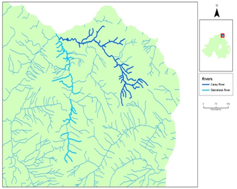
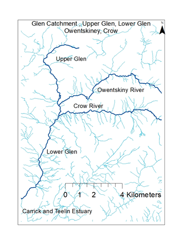
Table 1 Summary details of catchments illustrating catchment area, fluvial habitat area accessible to juvenile and adult salmon, nursery habitat spatially connected to or containing spawning habitat.
The Study Rivers are contained within a defined area of their banksides in times of normal flow and in all but exceptional spates. They flow through flow through peat and glacial gravel deposits, with erosion in upper reaches and sedimentation in the lower reaches. They are small enough to be fully assessed for their unique habitat structure by walkover survey over a few days after a spell of dry weather and are generally shallow with few places deeper than 1to 2 meters in non-spate conditions. They are typical spate rivers in that they rise and fall relatively rapidly in response to rainfall. Flood peaks reduce relatively rapidly providing 1 to 2 or 3 days of elevated water conditions facilitating migration of adults. Although the individual rivers drain spatially different riparian zones, the in river hydro-geomorphological habitat structures of nursery habitat connected to or containing spawning habitat enables a comparison of physical salmon habitat
Ballycastle North Antrim Margy Glenshesk and Carey
The total catchment for the Glenshesk and Carey, in Ballycastle is 118Km² with an upper altitude of 150 M and both rivers are responsive to heavy rainfall (DOE 2014).The lower drainage channels are wooded with patches of deciduous birch hazel and pasture, particularly in Glenshesk. These rivers confluence one Km from the sea to form the Margie river. Their upper catchments contain coniferous forestry which results in a high threshold for spate events when the catchment is unsaturated after a long dry spell. The Ballycastle rivers are situated in the North east of Ireland (NI), have around 900 mm rainfall/year (enclimate data).
Historically the Ballycastle river pair provided an anecdotal unquantified, “good” salmon and sea trout rod fishery of around two hundred salmon per annum (Peers Comm. Ballycastle Angling Club) and contributed to a commercial netting industry along the north coast of Northern Ireland, (Went, A.E., 1957). By the early1990s a much diminished almost non-existent stock barley remained. Dredging, flood engineering and river straightening in the middle reaches of the Glenshesk and upper reaches of the Carey resulted in the destruction of many pool riffle sequences and meanders which may have contributed to a salmon population decline. A local community hatchery project was instigated in 1994 to boost the almost extinct stocks, and anecdotal angling club reports indicate that there was an improvement with around 50 – 100 caught per annum by rod and line, though recent years 2014- 2019 have been poor years (Peers Comm. Ballycastle Angling Club). Salmon redds were observed in the middle to lower river in some cases, where they were observed prior to the collapse of the fishery in 1990s. In 2009 a decision was taken to limit hatchery stocking with swim up fry to areas where no natural spawning took place and where there was a paucity of spawning habitat within long tracts of nursery habitat. The Carey has a known higher alkalinity relative to the Glenshesk and maintains its spate water for a day or two longer than the Glenshesk. The Glenshesk has a tendency to rise and fall more rapidly than the Carey. The Carey’s natural hydro-geomorphology flow although maintained after rain from Lougharrema, “the vanishing lake” is also interrupted by a hydro scheme in its middle reaches which requires special fish migration mitigation measures. The hydro dam impacts the natural gravel flows process causing excesses of gravel downstream when the hydro dam is periodically flushed and reduces the natural gravel flows, with consequences for natural spawning downstream of the dam.
South Donegal Glen, Owentskinney, Crow
The Donegal rivers Glen, and its tributaries, Owentskiney, upper Glen and Crow have a total catchment of 123 Km² exist in an area of high annual rainfall around 1330 mm rainfall/year (enclimate data), draining open peat, with mostly highland sheep pasture. These three tributaries converge to form the lower Glen and are each assumed to contribute similar hydrology to the catchment as they are of similar length and catchment area. The river catchments are mountainous with an upper altitude of 350 M, 2.3 times higher than the Ballycastle rivers resulting in a higher propensity for spates.
The Donegal Glen, river enters the sea via Teelin harbour in south Donegal which has had a long tradition of salmon fishing and continues to exist as a wild fishery. Until relatively recent times it was a thriving commercial, cultural and angling resource (Taylor, L., 1981). Sporadic redd counts and surveys have been conducted with Inland Fisheries Ireland (Central Fisheries Board over the years) followed up by this researcher 2018 and 2019. Angling catches are reported to be around 100-200 pa (IFI, Slieve League Angling Club), though recent poor catches resulted in compulsory catch and release angling. There have been some drainage modifications over the years. However many pockets of stable spawning areas with attendant nursery are still evident through spread throughout the catchment.
Both the Donegal and Co. Antrim rivers have experienced destructive flood events in recent years and caused landslips in areas of high gravel deposits and have moved large amounts of river bed substrate. Despite hydro-geomorphological instability during severe rainfall events there are areas of stable spawning and nursery habitat which are naturally stable year on year. It is interesting that (De Vires2007) suggested that salmon can engineer their own spawning habitats over many years utilizing the same spatial area of habitat and this is bourne out by ideal spawning habitat being spatially fixed with observed spawning occurring year after year.
In county Donegal there is a strong desire to maintain the wild nature of the fishery. In Ballycastle County Antrim local discussions about a strategy for sustainability and enhancement vary in their commitment to a hatchery development strategy, some arguing that the hatchery has done its job of re-establishing a defunct salmon and sea trout run, while others argue locally that there would be no salmon at all to fish for without the hatchery. Importantly this analysis will help identify river habitat areas which need special protection, and those which might benefit from enhanced management such as habitat improvement schemes
Methodology
It is suggested in this analysis that defining salmon productivity as a function of nursery habitat proximally close to spawning i.e. nursery habitat containing spawning habitat and nursery habitat with spawning in close proximity) would provide an effective habitat based metric to determine potential productivity and conservation limits. Given the range of fry movement from a few meters to up to 400 m it was decided to quantify nursery habitat spatially and continuously connected to spawning habitat rather than using a specific cut of distance.
Field maps were produced at a scale of 1:5000 and the rivers walked to identify areas of nursery habitat downstream of spawning habitat or within spawning habitat and subsequently input to a GIS database. Nursery habitat directly connected downstream of spawning habitat was measured as far as a deeper pool area, bed rock or water fall. The spatial location of spawning habitat, and nursery habitat were recorded and quantified. Stream width x length was used to estimate the area of nursery habitat downstream of potential spawning habitat or where nursery habitat contained spawning habitat. River width was determined from low flow bankside width during low water flows. The study rivers are well contained within their drainage channels during low flows which enabled the survey. Subsequently the length of nursery habitat continuously connected to or within spawning areas was quantified.
Studies suggest that fry generally settle close to where they were deposited and need suitable nursery to thrive in a density dependent way.. The area of nursery habitat connected to or containing spawning habitat was assumed to be a functional habitat to support salmon fry from ova deposited in redds.
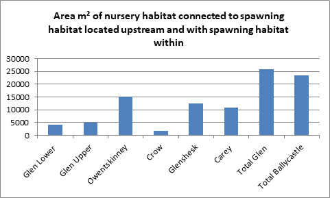
Figure 3. Chart representing quantities of nursery habitat in close proximity to spawning habitat in the five studied rivers.
Discussion
Key management questions, include are stocks likely to continue to decline? and can strategies be put in place to facilitate a harvestable surplus?
It is an understatement to say there are many spatial and temporal factors which make the modelling of individual salmon populations challenging. This study suggests that useful generalizations can be made regarding the quantity of nursery habitat in close proximity to spawning habitat in any particular salmon river. This study focused on nursery habitat in close proximity to spawning habitat as a baseline parameter. The area of nursery habitat in close proximity to spawning habitat as a subset of total fluvial area provides a differentiating quantum between the five studied rivers/ tributaries. Detailed habitat analysis as described provides a river specific assessment of habitat in individual salmon rivers with ramifications for estimating salmon populations more precisely than using a general temporal bayesian analysis, total fluvial area, nursery area, or spawning area on their own.
The key message in this paper is that the spatial location and quantity of specific habitats is unique in individual rivers and has a role in determining productivity and conservation targets of adult salmon with implications for river management. Since rivers differ in their physical hydro-geomorphological profile each river will have its own dynamic relationship between ova deposition, alevin survival, fry, parr and smolt output related to specific river hydro-geomorphological conditions and habitat. It is proposed that a salmon population is a function of a juvenile population determined by nursery habitat connected to spawning habitat and that productivuty potential and conservations can be determined form such habitat analysis.
It is postulated that the salmon population associated with each assessed river is reflected in the physical hydro-geomorphological habitat structure of its natal river. Subsequently it is possible to speculate that smolt output can be grounded spatially to nursery habitat connected to or containing spawning habitat within, via the succession of ova →,alevin →fry → parr→smolt . A conservation target can therefore be estimated by defining the number of adults required to optimally populate nursery habitat. Sea survival will determine adult return.
An example of how a habitat based productivity estimate and a habitat based conservation target could be identified is presented below in relation to nursery habitat proximally close to spawning habitat. Assumptions are made regarding ova survival in nursery habitat fry density dependence in nursery habitat and the relationship between the various life cycle stages (fry parr, smolt, returning adult).
Productivity
Figure 4 Suggested formula to estimate a habitat based productivity using survival ratios of fry/ova, parr/fry, smolt/parr, returning adult/smolt.
Juvenile productivity (Pj) as a function of nursery habitat downstream (Hn) of spawning habitat or containing spawning habitat.
. Pj = f(Hn)
Adult productivity (Pa) is presented as a function of juvenile productivity (Pj) summarized as
Adult productivity = f (Ax Bx Cx Dx E)
Where
A =Nursery Habitat Area connected to spawning habitat or containing spawning habitat.
B = Fry Density/m²
C = Fry to Parr survival ratio ie parr/fry
D = parr to smolt survival ratio i.e. smolt/fry
E = smolt to adult survival ratio i.e. adult/smolt
In the presented example an arbitrary fry density of 1fry /m² in nursery habitat was used to estimate fry numbers (Eggilshaw 1982). The area of nursey habitat spatially downstream of spawning habitat, and that containing spawning habitat was quantified and used to determine river population as habitat area x an assumed fry density of 1/m² (Eggilshaw 1992). Subsequent estimates of parr, smolt and adult survival ratios were determined by inference from literature estimates of survival and personal judgement In the example provided a 0.18 parr/fry ratio is assumed and a 0.43 smolt/parr ratio (Jokikko 1998) are assumed to become smolts. Whilst the 1fry/m² figure may seem arbitrary it suggested as a reasonable abundance level based on a fully- quantitative study carried out within the river Carey (Northern Ireland Environment Agency, /AFBI), which demonstrated survival of fry at around 1 /m² and inferred by (Eggilshaw 1982). Sea survival of smolts to returning adults was presented for 0.03, 0.10, and 0.20 adult / smolt ratio. The product of total river m² area of relevant nursery habitat area and juvenile fry population estimated at 1/m² was used to estimate of the potential population/productivity for the five rivers assessed. It is anticipated that during years where ova to fry survival is poor due to prevailing environmental conditions a greater number of ova from female fish would be required to achieve the target of 1/m² in nursery habitat spatially close to or containing spawning habitat. In years where ova to fry survival is high, fewer adult fish would be required to fill nursery habitat to its density dependent estimate limit target of 1/m². Ultimately further work to calibrate fry density abundance in nursery habitat over many years would determine a relevant density dependent scaling factor relevant to water quality parameters.
Conservation limit (Target)
The presented methodology argues for a spatially fixed habitat model for individual rivers, to compare salmon conservation limits between individual rivers reflecting the unique saptial proximity of nursery and spawning habitat.
Since adult females carry a finite number of eggs, the number of adult fish required to deposit a specific number of ova can be defined (White 2016, Eggs = 505 +1250x weight (kg) average weight 2.5g (Pers.comm) and used to calculate a female based conservation limit. It was assumed that3625 eggs were carried per female. The term “limit” is used as any further ova deposition will not increase fry productivity which is also described “hockey stick”, stock recruitment curves.The term conservation target may be more appropriate where it obvious that the salmon population in a specific river is declining and defined annual conservation limits are not being met.
The conservation limit is defined in this study as the number of adult salmon required to deposit sufficient ova in nursery habitat to achieve a target fry density of 1/m² in nursery habitat containing spatially connected to spawning habitat upstream or within. A conservation limit or target of female egg carrying adults was estimated by working backwards from a pre-determined fry abundance of (1/m²) in nursery habitat assumed to be representative of density dependent survival in suitable fry nursery. The calculated upper and lower rage estimates for hierarchical survival form fry→ parr→ smolt are explained by variations in losses due to natural mortality. For example, by ova being washed away, unfertilized, genetically non-viable ova, predation, poor water quality, pollution events, adverse environmental/climatic conditions such as high water flows. Fry density survival range ratios of fry/ova, of 0.03, 0,09 and 0.20 were selected to estimate the number of ova required to achieve a fry density of 1 fry /m squared is based on results from a previous ova to fry survivability study( Kennedy 2012). As with the productivity estimate fry to parr survival is calculated as a parr/fry ratio of 0.18 based on river Carey fully quantitative survey (NIEA/AFBI). Smolt/fry survival is calculated at 0.15 – 0.43Jokikokko (1998), using the upper limit, 0.43. Sea survival of smolt to returning adults is presented as adult/smolt ratio of 0.03, 0.10 and 0.2 (peers comm. Bushmills). The conservation limit range for the required number of females was increased by 1.5 to account for necessary numbers of male fish to fertilize eggs during redd cutting (spawning).
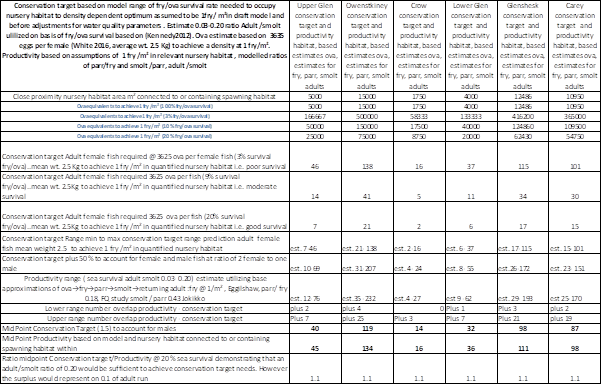
Table 2 Trial reconciliation of a conservation target range with estimated productivity range. The number of adult fish required to fill close proximity nursery habitat the guide target productivity potential of 1.0 /m² using the assumption that between 3 and 20% of ova will survive (Kennedy 2012). Each female fish is assumed to carry 3635 ova (White 2016) (average weight of 2.5 Kg pers.comm Ballycastle angling Club) average catch weight), and using a weight ova calculation from White 2016. The survival of ova to fry is estimated at fry/ova ratio of 0.03- 0.20 (Kennedy 2012) from the river Bush Northern Ireland which is a spatially close index river with similar river characteristics and is used to estimate a range for conservation limit requirements. Habitat based conservation target of ranges are achievable with smolt/parr ratio of 0.02 sea survival assuming juvenile habitat based survival life cycle survival. According to selected juvenile productivity parameters habitat a sea survival ratio of adult /smolt of 0.2 would secure achievement of conservation target. Sea survival >20 % is required for harvestable surplus. Subsequent adjustments may be needed to adjust for water quality parameters effecting survivability
Low sea survival of smolts will result in otherwise smaller numbers of adult salmon returning to spawn for equivalent number of smolts leaving their natal river. The proposed model suggests that with sea survival below 0.20 adult/smolt ratio there is a risk of insufficient adult fish to ensure nursery in close proximity to spawning habitat was filled to capacity with fry and that conservation limit (target) was attained. The model suggests with its key assumptions regarding juvenile life cycle survival ratios that a sea survival of adult/smolt ratio at round 0.20 is required to ensure that habitat based smolt output is sufficient to meet the habitat based conservation target.
In reality further studies will be needed to calibrate fry abundances in specific rivers as a consequence of chemical parameters in addition to physical habitat as defined but are likely to be approximately 1 /m² in unpolluted rivers dropping to well below this in polluted rivers. Calibration of optimum fish density in nursery habitat for specific rivers would define adjustments necessary adjustments to the habitat life cycle model presented. For example, the Carey is buffered by limestone due the influence of Loughareema resulting in high alkalinity levels which is likely to influence fish populations in equivalent nursery habitat elsewhere. During hot summer days the Glenshesk is reported to be a few degrees cooler than the Carey due its steep, wooded, shaded valley of birch and hazel. Such factors will relatively alter the specific abundance of juvenile salmon in their habitats and impact the estimated productivity range and conservation target. A series of semi quantitative electro-fishing studies suggests that in equivalent physical habitat there are almost twice as many fry in the Carey as in the Glenshesk (AFBI). Further studies are needed to calibrate the proposed model accounting for local water quality and riparian parameters.
Consequently the survival ratios fry/ova, parr/fry, smolt/parr, will vary from river to river relative to water quality parameters in addition to physical hydro-geomorphological habitat units. Individual rivers will require annual monitoring over many years to determine the natural optimum density of juveniles in local nursery habitat and the extent to which water quality parameters impact survival and life cycle population bottlenecks. Ultimately hatched fry competitively accommodated in nursery habitat will provide a measure of smolt output, and the necessary adult return habitat based conservation target.
Individual rivers will have additional productivity constraints determined by water quality parameters such as pH, CaCo₃, fine sediment, phosphate, nitrogen, biological oxygen demand which will impact productivity in habitat. Anecdotal evidence suggests that good quality physical habitat for salmon can be dominated by stoneloach (B. barbatula) when water quality is compromised. Of interest positive associations with pearl mussel (Margritifera) and salmon may be apparent and there is evidence pearl mussel can stabilise in stream geomorphology (Quinlan 2015).
The Donegal habitat analysis indicates a relatively high proportion of nursery habitat in close proximity to spawning habitat in the Owentskiney, with very little in the Crow and an intermediate quantity in the upper Glen. The Owentskiney is therefore likely to be a major source of salmon fry followed by the upper Glen where there was a lessor area of nursery habitat in close proximity to spawning habitat. The Crow has very little nursery habitat in close proximity to spawning habitat due to there being very few areas of spawning habitat identified. That is not to say that the Crow is unproductive as a juvenile salmon habitat or that areas of nursery habitat without the attendant spawning habitat are unimportant. Older developing salmon parr may migrate into such distant nursery. There are significant areas of nursery habitat suited to growing fry and it may well be that these are occupied by older developing parr and or trout. The Crow river may therefore be a source of smaller trout/ sea trout as smaller fish probably don’t require such specific spawning sites and ova are dispersed more randomly as opposed to larger salmon or larger sea trout.
With regard to a conservation target the analysis suggests that relatively high numbers of female fish are required in the Owentskiney at spawning to ensure sufficient ova deposition as there are many areas of nursery habitat with spawning habitat upstream or containing spawning habitat. A lessor number are required in the upper Glen and only a very small number if the Crow river. The lower Glen is a wider deeper and faster flowing than the tributaries collecting water from all three and provides many pools for fish as they await spawning time where they are vulnerable to being exploited by anglers and others. A relatively small number of spawning sites on the lower Glen accommodated a large number of redds. Redd counts in 2019 and 2018 revealed a large number of redds on two sites in particular. It is conceivable that the lower Glen is sufficiently populated at spawning time to ensure fry survival and parr survival is optimised in the available nursery habitat. The bigger and deeper the river, with increasingly gravels and cobbles it is likely that older fish i.e. parr can survive and preferentially out compete smaller fry. It is therefore possible that the lower river may may accommodate more parr relative to the upper river and affect an increase in parr relative to fry whilst also accommodating adult fish securely prior to their final spawning run in late autumn and early winter. The upper tributary catchments drain to a lower hydrology level relatively quickly after rainfall which would make adult fish more vulnerable to predation in the upper tributaries. Adult fish require freshets to navigate to the main spawning sites in November and December to spawn successfully.
The quantity of nursery habitat spatially close to spawning habitat in the Owentskiney suggests a greater number of adult fish are required at spawning than upper Glen and the Crow. This analysis therefore points to a quadripartite management strategy for the Glen river and potentially a spatial separation of different spatially distinct salmon populations. Given that the tributaries represents one third of the catchment and are relatively shallow in relation to the main river adult salmon may require greater protection from predation at spawning time.
Identifying a comparative quantitative factor, such as nursery habitat in close proximity to spawning habitat would assist in defining rivers relative to each other and determine spatial management priorities. For example, where nursery habitat and spawning habitat exist together high natural productivity of juveniles would be expected. Where long tracts of suitable nursery habitat exist without the attendant close proximity spawning habitat it would be possible to leave such areas to older trout and or older salmon parr or consider stocking with genetically suitable ova fry or parr or. It is intuitive to suggest that stocking such nursery habitat would add substantially to fry and parr numbers. However the genetic consequences of stocking have been well discussed over the years and the current consensus is that stocking should only be used when absolutely necessary perhaps after a complete collapse in population stocks. However the potential negative genetic consequences of stocking salmon artificially are well established in the scientific literature due to genetic population alterations (Verspoor 2007).
A key management challenge is to achieve maximum adult returns linked to juvenile life cycle units, including ova deposition, alevin hatching, fry survival , parr survival, and ultimately smolt output. The aim is to ensure that sufficient adults are enabled to optimally populate nursery habitat relative to a habitat based conservation target for individual rivers and tributaries. Exploitation above the conservation target should only proceed when there is confidence that a habitat based conservation target is met. Habitat assessments coupled to juvenile electro-fishing in representative habitats would determine an appropriate habitat scaling factor for individual rivers and provide a measure of juvenile population health. Smolt output could then be correlated to habitat profile for individual river populations of salmon and an output productivity estimated. Autumn /winter redd counts and summer electro-fishing population density surveys should be used to calibrate nursery sites to subsequent density occupancy densities for fry and parr in particular rivers.
The hydro-geomorphological condition of rivers has been incorporated into the Water Framework Directive (WFD) with some rivers classed as “heavily modified” but this does not provide a full assessment of the impacts and opportunities for salmon populations within individual rivers. There is therefore an urgent need to ensure that salmon habitats are assessed hydro-geomorphologically, as an integral function in the development of salmon management plans in addition to current fishery protection and river management measures in place. A comparative habitat analysis between many more rivers as described would clarify why some rivers with large tracts of fluvial area are less productive than some small streams with very good habitat profile and good water quality. Importantly it needs to be recognised that whist most adult salmon will enter the river long before spawning they will reside in the deeper pools of the lower river until spawning time in November and December. Deeper pools providing a secure refuge until fish are ready to spawn is also a significant measure of the hydro geomorphology and it is the deeper pools which provide most of the angling /exploitation opportunities.
Temporal associations between historic adult returns and smolt output are currently monitored by fishery monitoring organisations (DAERA, AFBI, IFI, Loughs Agency in Northern Ireland, Inland Fisheries Ireland IFI in ROI, Tweed Foundation in Scotland and Fisheries Boards in Scotland). Environment agencies monitor, water quality factors such as pH, hardness, sediment, impoundments, interrupted upstream and downstream migrations, low and excessive water flows, within the context of the WFD and contribute to salmon management plans. It may be obvious that water quality factors such as pH pollution, excessive fine sedimentation will also impact salmon productivity. Individual river habitat structuring, is a missing link in quantifying potential productivity and conservation targets. It is critical to natural sustainability that conservation and management targets are defined in a way which accounts for in river “hotspots” for juvenile recruitment survival and smolt output. A deeper understanding of the hydro-geomorphological condition of individual rivers in relation to the spatial location of specific life cycle units, reported as areas of m² of nursery habitat spatially connected to spawning habitat would provide a baseline proxy to compare potential productivity and conservation needs of individual rivers
Similar habitat analyses as described in many more rivers are likely to suggest that the hydro-geomorphological profile of the rivers differ in the quantity, and interconnectedness of spawning and nursery habitats. Limited nursery habitat in combination with attendant spawning habitat and competitively driven fry survival will enforce a production bottleneck. Identifying and quantifying parr preferred habitat more suited to growing parr would provide useful additional analysis.
In summary all life cycle stages need to thrive according to the bottlenecks and population size determined by river hydro-geomorphology. Quantifying salmon nursery habitat proximally close to spawning habitat provides a useful relative indicator of population size between rivers. The management of rivers as the sources of Atlantic salmon need to be managed in a way that facilitates hydro-goemorphological habitat life cycle habitat units are maintained and or restored where appropriate to ensure sustainable salmon populations. Further suites of spatial and continuing temporal analysis to estimate life cycle unit densities in particular habitats collected from many rivers over many years would develop and enhance the predictive power of any population model.
The use of a simple GIS recording system as described, supported by a strong community led desire to manage salmon rivers effectively would facilitate detailed habitat mapping of individual salmon rivers. Finally a quote from Inland Fisheries Ireland states, “The decline in salmon and sea trout stocks has been ascribed to factors such as climate change, marine mortality, diseases, parasites and other factors all of which have been well studied and described. Some of these factors are controllable, but many of the most significant ones, such as marine mortality are not. The focus then has to be on controlling the factors we can control. This includes ensuring our rivers are producing the highest quality smolts, giving them the best chance of survival and maximising t[i]he number of adult fish being released to spawn.” (IFI 2017).
I would be interested to hear from other salmon and hydro-geomorphology experts to further discuss the importance of identifying protecting and enhancing productivity hotspots such as nursery habitat in close proximity to spawning habitat. Similar analysis across many more rivers would certainly be a useful addition to the development of salmon management strategies and identify areas for special protection.
References avaiable on request